Milton grew to a hurricane Sunday as it continued on an ominous path toward Florida, where officials are scrambling to clear debris from Hurricane Helene and prepare for what they said may be the biggest evacuation since 2017’s Hurricane Irma.
The storm, which had 80-mph sustained winds at 2 p.m. Sunday, was about 815 miles west-southwest of Tampa and moving east at 6 mph.
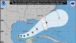
It is forecast to grow into a major Category 3 storm with 125 mph of bluster before making a landfall along Florida’s Gulf Coast on Wednesday.

Milton will be gorging on extremely warm Gulf of Mexico waters over the next few days, giving it the fuel to rapidly intensify, which is “explicitly forecast” in the NHC’s prediction.
The center of Milton’s track cone takes it into the heavily populated Sarasota area at landfall but there was a potential early Sunday for it to hit the coast anywhere from Marco Island to the south to near Horseshoe Beach in the soft Big Bend region to the north.

A storm surge inundation map released at 11 a.m. by the NHC shows the potential for more than 9 feet of water flooding into vulnerable Tampa Bay, Charlotte Harbor, and Fort Myers Beach. But a little wobble in storm track makes a big difference. If the storm heads farther to the south, it could mean offshore winds in Tampa that would push water away from the coast.
NHC Director Michael Brennan cautioned against focusing too much on Milton’s cone Sunday, noting that the average track error three days out is about 100 miles.
“We are also expecting Milton’s wind field to grow in size as it approaches the Florida peninsula, so we are going to see the widespread impacts of life-threatening storm surge inundation and dangerous hurricane-force winds on both coasts and across portions of the peninsula,” Brennan said.
With Milton’s track shifting slightly south on Sunday, the chances for sustained tropical-storm force winds in West Palm Beach increased to 55% beginning late Tuesday into early Wednesday. Fort Lauderdale’s chances were upped to 46% and Miami had a 26% chance.
The chances for hurricane-force winds in West Palm Beach were 8%, with Fort Lauderdale at 6% and Miami at 2%.
Gov. Ron DeSantis declared a state of emergency Saturday in 35 counties ahead of the storm, including Palm Beach County, the Treasure Coast and Broward, Miami-Dade and Monroe counties. Sunday morning, a further 16 counties were added, for a total of 51.
DeSantis said in a news conference Sunday morning that he was pulling back people sent to help with Hurricane Helene recovery in North Carolina and Tennessee so they would be in place ahead of Milton’s landfall. Debris removal is operating around the clock, he said, with multiple agencies pitching in including the Florida National Guard, Florida Department of Transportation and the Florida Highway Patrol.

Hurricane Helene made landfall in the Big Bend region of the state as a Category 4 hurricane Sept. 26, scouring barrier islands, washing away homes and pushing a storm surge inland nearly the length of the peninsula’s west coast.
DeSantis also urged storm-weary residents of the Gulf Coast to restock their hurricane supplies.
“You have time to prepare. All day today, all day Monday and possibly all day Tuesday,” he said. “If you are anywhere near the cone, certainly you should prepare for power outages.”
Kevin Guthrie, Florida’s director of emergency management, said Sunday that the evacuation for Milton could be the largest the state has seen since Hurricane Irma in 2017 when an estimated 6 million people fled. The massive exodus caused lengthy traffic jams as some people, some of whom were not in evacuation zones, tried to drive as far north as Georgia.
“Evacuate if you are in an evacuation zone,” Guthrie said. “If you are not in an evacuation zone, and your home was built by Florida building code, you may be able to stay in place.”
For South Florida’s east coast, heavy rainfall and flooding is expected, and there is a flood watch in effect through Thursday morning.
More:2024 hurricane season: Yes, we had Debby and Helene, but October is Florida’s peak season
The National Weather Service in Miami said it is too early to know exactly how Milton will impact Palm Beach, Broward and Miami-Dade counties but that “all potential impacts are in play,” including strong winds, storm surge, flooding, heavy rainfall and tornadoes.
Heavy rainfall in South Florida through Tuesday is not associated with Milton, but could reach nearly 7 inches in West Palm Beach and 8 inches in Miami and Fort Lauderdale. NWS Miami meteorologists cautioned that whatever rain comes with Milton later in the week will “exacerbate the threat” of flooding.

Milton is predicted to move swiftly across the peninsula after landfall and is forecast to maintain hurricane strength through its exit into the Atlantic Ocean.
That means the Treasure Coast through the Space Coast could get tropical storm-force or hurricane-force winds. Brevard County will have sandbag distribution sites set up Monday, and county officials urged residents to prepare.
“The main message now is for people to evaluate their risks, have a plan in place and be ready to execute that plan as this system approaches,” said Don Walker, Brevard County spokesman.
Okeechobee County officials Sunday also offered free sandbags for residents at its Public Works Department.
NHC meteorologists said weather models are in generally good agreement on the path Milton will take, first being steered east before getting picked up by a trough digging into the Gulf of Mexico and whipped at Florida.
There is less confidence in the intensity forecast, which is wrought with complexities.
Milton is a small storm, which means it can both strengthen and weaken rapidly. While it is in a favorable environment for deepening, it will also hit wind shear and dry air Tuesday. NHC forecasters said some models have Milton rapidly weakening over water after reaching peak intensity. Others have it weakening only slightly.
Florida Today reporter Michelle Spitzer contributed to this story.
Kimberly Miller is a journalist for The Palm Beach Post, part of the USA Today Network of Florida. She covers real estate, weather, and the environment. Subscribe to The Dirt for a weekly real estate roundup. If you have news tips, please send them to kmiller@pbpost.com. Help support our local journalism; subscribe today.


