The National Hurricane Center is forecasting that a major Category 3 hurricane will hit a battered Florida Gulf Coast midweek, a tripling of misery for a region that has already suffered two hurricane landfalls this season.
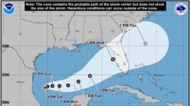
An advisory issued at 5 p.m.. Saturday on newly formed Tropical Storm Milton says the tropical cyclone is 245 miles north of Veracruz, Mexico, in the simmering southwestern Gulf of Mexico and moving north-northeast at a dawdling 3 mph. Its maximum sustained wind speeds were 40 mph.
Rapid strengthening is expected as the system moves across the central and eastern part of the Gulf with a hurricane forming Monday or Tuesday before more deepening will take it to a Category 3 storm with estimated 115 mph winds ahead of a Wednesday landfall.

While NHC’s intensity forecast tops out at a Category 3 hurricane, some models are more bullish on the storm’s future ferocity and the 5 p.m. advisory noted that “upward adjustments could be required.”
“I’m not an alarmist, it takes a lot to get my attention. This has it,” said Jeff Berardelli, a meteorologist for Tampa-area News Channel 8 in a social media post.
Forecast track models are in consistent agreement for now that the storm will make landfall somewhere between Naples and Cedar Key with the forecast cone issued Saturday by the NHC swallowing the entire Florida peninsula. The average 4-day forecast error is 150 miles, roughly the distance between Naples and Tampa.

More:2024 hurricane season: Yes, we had Debby and Helene, but October is Florida’s peak season
For Palm Beach, Broward and Miami-Dade counties, the National Weather Service continues to forecast the potential for heavy rainfall of up to 10 to 12 inches through Oct. 12, but cautions that rainfall totals will fluctuate as Milton gets closer.
Also, heavy rains that fell Saturday and are forecast to pick up on Sunday are not associated with Milton, meaning whatever Milton does bring will be falling on saturated ground.
A flood watch was issued for all of South Florida beginning Sunday through Thursday morning.
The forecast is likely to change in the coming days but as of Saturday, Palm Beach County has about a 40 to 50% chance of feeling tropical storm-force winds beginning late Tuesday or early Wednesday, according to the NHC.
Meteorologists in the National Weather Service office in Miami, which also forecasts for Naples, were more specific, saying West Palm Beach has a 41% chance of getting sustained tropical-storm force winds of 39 mph or higher through Wednesday night.

Fort Lauderdale has a 37% chance, with Miami having a 20% chance.
The chances for hurricane-force winds through Wednesday night are 4% for West Palm Beach, 3% for Fort Lauderdale, and less than 3% for Miami.
They noted that it was too early Saturday afternoon to predict potential storm surge totals but that “all potential impacts are in play at this time.”
That includes strong wind, storm surge, flooding rainfall, and tornadoes.
More:Hurricane Season 2024: Tips for starting a storm supply list
Fox Weather hurricane specialist Bryan Norcross said residents on the Gulf Coast should prepare for a “significant” storm surge event.
“Things are going to change fast, so plan to stay informed,” he said in his Hurricane Intel blog. “Don’t pay attention to individual computer forecasts. As always, they are expected to jump around as the system develops.”
If Milton’s forecast holds true, it will be the fifth hurricane landfall in the continental U.S. this season and the third for Florida’s vulnerable Gulf Coast. Hurricane Beryl, which became the earliest Category 5 hurricane on record when it deepened in July, made landfall in Texas as a Cat 1 on July 8.
Debby hit Steinhatchee, Florida, as at Cat 1 on Aug. 5. Francine reached the Louisiana coast as a Category 2 storm on Sept. 11. And Cat 4 Hurricane Helene brought havoc to Florida’s west coast on Sept. 26, sending a lengthy storm surge that flooded homes as far south as Fort Myers Beach and left them in splinters in the Big Bend region.
“Florida, it’s time to take some precautions,” wrote NHC senior hurricane specialist Erik Blake in a social media post. “Gas and grocery for me today. The trend is not our friend. Pay attention for future updates.”
Forecasts for the 2024 hurricane season overwhelmingly called for an above average 6-month spat of storms. A fast start led into a head-scratching lull and now a heartbreaking ramp-up. As of Oct. 4, the season was above normal for the date with the 12 named storms (the average through Oct. 4 is 11), and eight hurricanes, when the average is five.
It’s rare, but not unprecedented, for an area to get hit by three hurricanes in a single season. In 2020, Louisiana’s coast was hit by hurricanes Laura, Delta and Zeta. In 2004, an area south of Winter Haven had hurricanes Charley, Frances and Jeanne run through it.
Kimberly Miller is a journalist for The Palm Beach Post, part of the USA Today Network of Florida. She covers real estate, weather, and the environment. Subscribe to The Dirt for a weekly real estate roundup. If you have news tips, please send them to kmiller@pbpost.com. Help support our local journalism; subscribe today.


