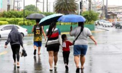
THE Philippine Atmospheric, Geophysical and Astronomical Services Administration (Pagasa) placed several areas in Luzon and Visayas under Tropical Cyclone Wind Signal (TCWS) Number 1 on Sunday, September 1, 2024, due to the low-pressure area-turned-tropical depression “Enteng.”
In an advisory, Pagasa said Enteng was last spotted 120 kilometers (km) north-northeast of Borongan City, Eastern Samar, or 150 km east of Catarman, Northern Samar, with maximum sustained winds of 45 km per hour (km/h) near the center, gustiness of up to 55 km/h, and a central pressure of 1002 hPa, moving northwestward at 30 km/h.
TCWS No. 1 was hoisted over the following areas:
* Eastern portion of Camarines Sur (Presentacion, Garchitorena, Caramoan, Calabanga, Naga City, Pili, Bombon, Magarao, Ocampo, Baao, Nabua, Bula, Balatan, Bato, Milaor, Minalabac, Camaligan, Sagnay, Iriga City, Buhi, Tigaon, San Jose, Goa, Siruma, Tinambac, Lagonoy, Canaman, Gainza, San Fernando)
*Catanduanes
*Albay
*Sorsogon
*Burias Island
*Ticao Island
*Northern Samar
*Samar
*Eastern Samar
*Biliran
*Northeastern portion of Leyte (Babatngon, San Miguel, Tacloban City, Alangalang, Santa Fe, Palo, Barugo)
The weather bureau said these areas may experience strong winds in the next 36 hours with minimal to minor threat to life and property.
Pagasa said Enteng may reach the tropical storm category and landfall and passage over the localities in the Bicol Region-Eastern Visayas area is not ruled out within the next 48 hours.
It may potentially reach a severe tropical storm category by Thursday, September 5. (TPM/SunStar Philippines)


