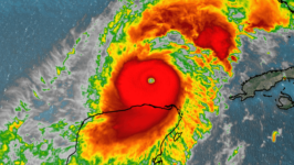
Hurricane Milton regains Cat. 5 status
Hurricane Milton has survived its eyewall replacement cycle and strengthened back into a Category 5 storm with sustained winds of 165 mph, gusting to 200 mph according to the 5 PM update from the National Hurricane Center.
The tropical cyclone weakened after reaching its peak intensity of 180 mph sustained winds Monday night around 8 PM. By Tuesday morning, Milton was a Category 4 storm, with winds of 145 mph and a minimum pressure of 929 mb.
The decrease in intensity is a common side effect of the eyewall replacement cycle.
Hurricane Milton continues to spin in the Gulf of Mexico tonight. The latest reconnaissance data from the Hurricane Hunters suggest Milton could be even stronger than the 5 PM update suggests.
The 902 mb being measured by the Hurricane Hunters would put Milton’s intensity back close to where it was on Monday night.
As for the forecast and track of the cyclone, there have been some slight tweaks. The National Hurricane Center has shifted the storm a nudge south.
This would have major implications on the Tampa Bay region and the amount of storm surge. If Milton were to make landfall south of Tampa, there could be a repeat of Hurricane Ian, resulting in Tampa experiencing a reverse surge. For now, the official forecast still has 10-15 feet of storm surge stretching from Tampa to Venice.
The heaviest rainfall associated with Milton will be observed north of the center of circulation, flooding the I-4 corridor.
For the latest updates, stay with Storm Team 10.


